Full planning application
The detailed planning application submitted to South Staffordshire District Council is for new homes and green open spaces to the east of the A449, opposite the existing neighbourhood recently delivered by Bloor Homes. The plans comprise:
- 135 high quality homes in a mix of styles, including 2, 3 and 4 bedroom family homes, as well as 1 and 2 bedroom bungalows suitable for downsizers.
- 54 of the new homes (40%) will be affordable homes, including socially rented, shared ownership and First Homes.
- Extensive green public open space, including the first part of Penkridge’s new Riverside Community Park, opening up public access to the western riverside at this location for the first time.
- Extensive planting of new trees and habitat creation, delivering Biodiversity Net Gain well in excess of 10%.
- New children’s play area
- The first section of a new active travel route built to the latest standards which will extend from Penkridge village to serve the wider Penkridge North development as future phases come forward.
- Financial contributions to enhance key services and infrastructure in Penkridge, including healthcare and education.
The planning application is a Full Planning application, including details as the layout of the new neighbourhood, landscaping and public spaces, and house designs.
Neighbourhood layout
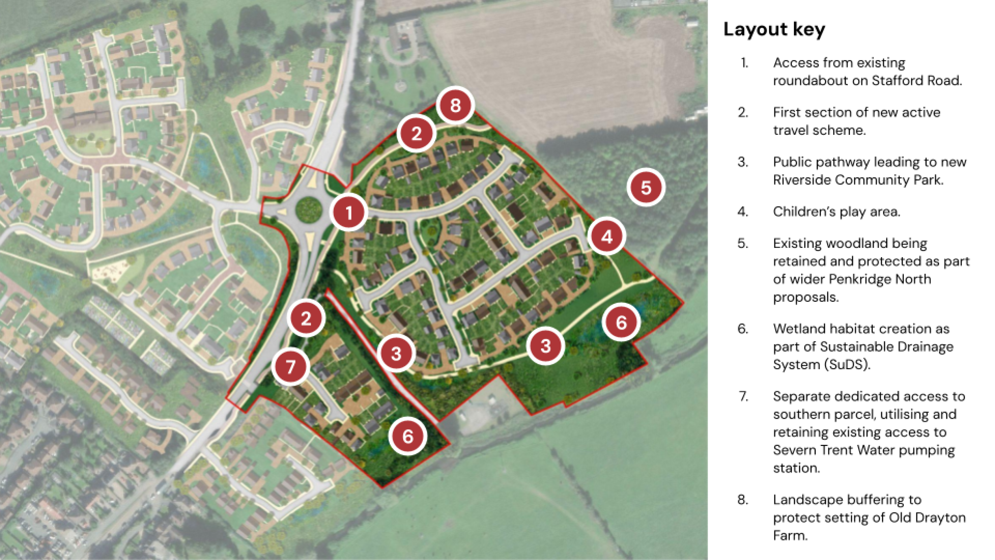
The layout for the proposed Bloor Homes development in Penkridge can be viewed below. The new homes and green public spaces will be located on the eastern side of the A449 Stafford Road, directly opposite the first phase of the development which is nearing completion. Access to the majority of the development will be taken via a new spur from the existing roundabout. A small number of homes will be served by a separate dedicated access a short distance to the south where there is an existing access serving the Severn Trent Water pumping station.
The plans represent the first phase of the wider Penkridge North proposals, which are informed by a draft allocation for new homes and community facilities in South Staffordshire District Council’s emerging new Local Plan. Bloor Homes proposed development forms the south eastern parcel of the wider proposed neighbourhood, which you can view on our interactive map here.
New homes
The first phase of the new neighbourhood will comprise 135 high quality new homes in range of styles and sizes, including 2, 3 and 4 bedroom homes. There will also be a number of bungalows providing options for those who may wish to downsize into a more manageable home.
Affordable housing
40% of the new homes (54 properties) will be affordable homes, in a range of different tenures:
Social Rent - 27 of the affordable homes will be for social rent through the local authority/local housing association.
Shared ownership – 13 of the affordable homes will be a mix of 2 and 3 bed shared ownership properties. This is a more affordable way for people to buy their own home. Under shared ownership, the purchaser buys an initial percentage of the property, between 10% and 75%, and pay a reduced rent on the rest to a local housing association.
First Homes – 14 of the affordable homes will be a mix of 2 and 3 bed First Homes. First Homes are homes that are sold on at a discount of at least 30% against the market value, and with a price cap of £250,000 applied. Eligibility criteria apply that ensure they are only available to people on lower incomes such as key workers. When a First Home is sold to its first owner, a legal restriction is entered onto the Title Register. This restriction is intended to ensure that the title cannot be transferred to another owner unless the relevant local authority certifies to HM Land Registry that the First Homes criteria and eligibility criteria have been met, including the discounted sale price.
Design and appearance
Building heights
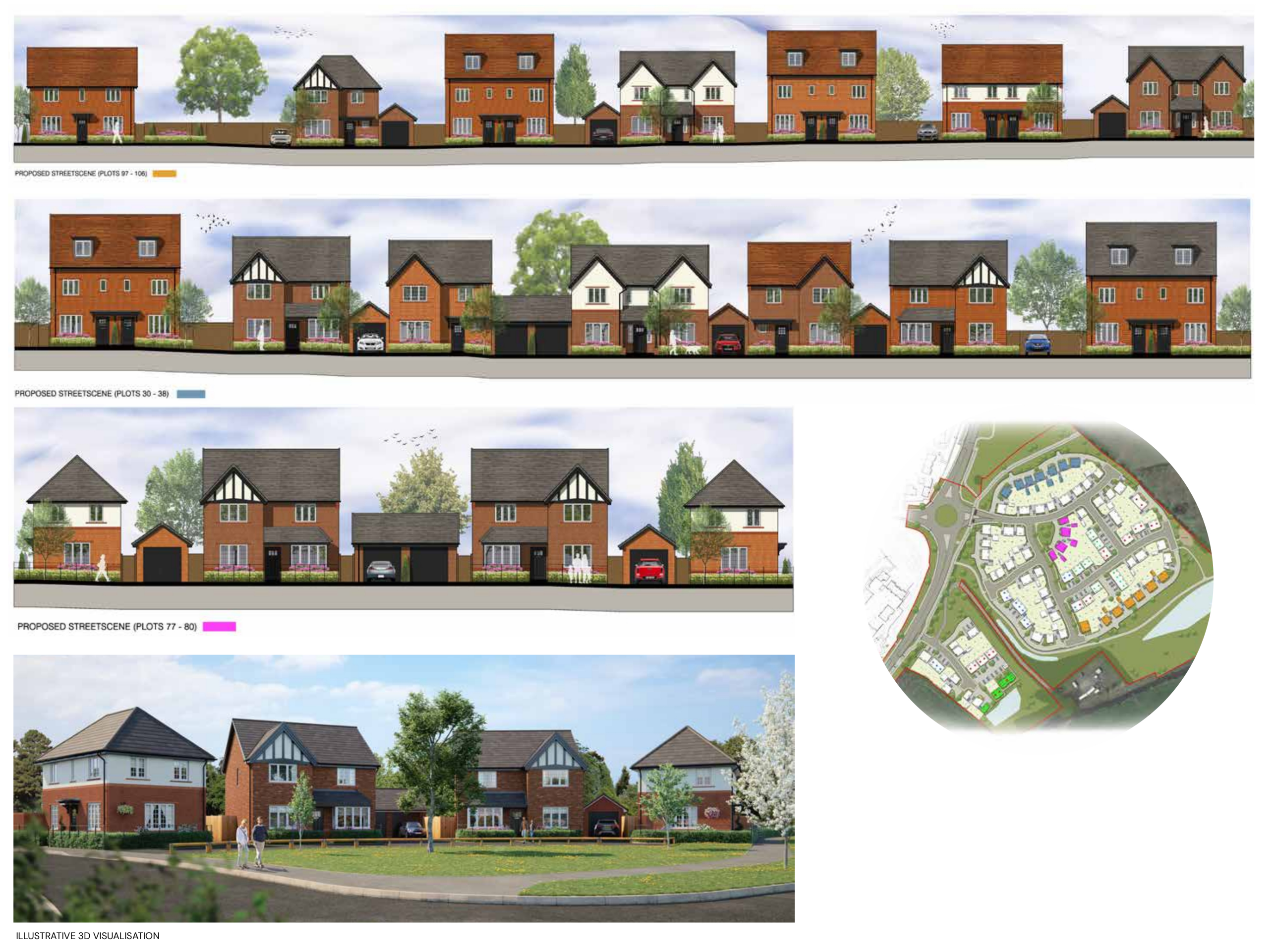
The new neighbourhood will primarily consist of 2 storey homes, reflecting the typical height of development seen in the surrounding residential area.
There will also be some bungalows within the development and on the eastern edge.
In addition, a limited number of 2.5 storey homes (2 storey homes with dormer windows within the roof space) have been used along key frontages to create focal points and add variation to the roofscape, including a small grouping forming a backdrop to the focal open space at the main entrance.
There is one 3-storey building located on the southern edge, positioned to take advantage of views across the River Penk to the south but set back beyond a landscaped buffer and SuDS area.
Buildings around the edges of the site will include feature gables and hipped roofs to add variation in roof profile and massing, mainly using detached housing and garages. This will be more formal, with repeating and symmetrical elements along the northern edge close to the A449 corridor and strategic active travel route. Less formal housing, with greater variety in house-types, will be located along the southern edge, fronting on to the River Penk corridor.
Appearance
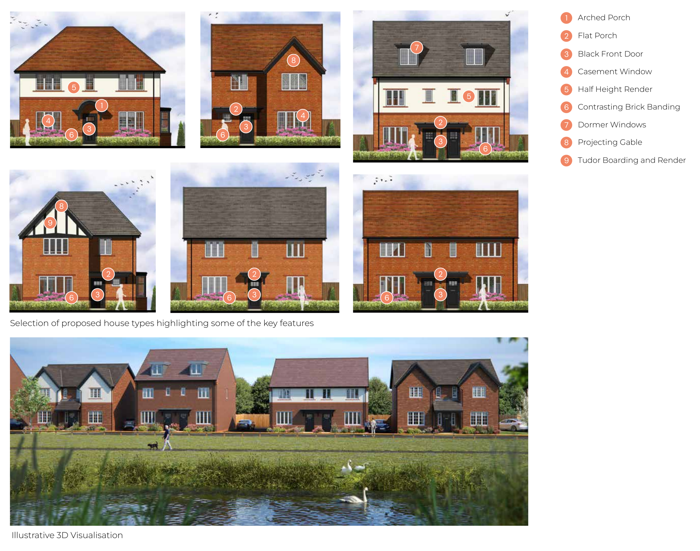
The appearance of the new homes will reflect the existing vernacular locally, informed by the existing Bloor Homes neighbourhood as well as elements of the materials and architectural cues of traditional homes in Penkridge village centre.
Proposed streetscenes - Click image to enlarge
Design precedents - Click image to enlarge
A selection of the proposed house types showing design features - Click image to enlarge.
Landscape and open spaces
As shown in the layout image above, the plans are characterised by extensive tree planting and green spaces, providing a green setting for the new homes, as well as new publicly accessible spaces for the wider community, including the first phase of the wider Riverside Community Park.
In addition to new planting and the incorporation of green corridors, there will also be the creation of wetland habitats through the implementation of sustainable drainage systems (SuDS).
Biodiversity Net Gain
New planting and creation of habitats will deliver Biodiversity Net Gain significantly in excess of the 10% that is expected to become the minimum requirement for development once regulations within the Environment Act are adopted.
Access and movement
Active travel
The development has been designed to prioritise access for pedestrians and cyclists and will provide the first part of the proposed strategic active travel link that will link the village centre to the Community Hub in the wider Penkridge North neighbourhood. Designed to LTN/120 standard, the strategic active travel link will provide a 3m wide 2-way cycle path and a 2m wide pedestrian path. The route will extend form the site’s northern boundary running south through a green corridor to the site vehicular access from the A449. A priority crossing will be provided over the access road and from there it will run along the eastern side of the A449 itself towards the village centre.
A signalised crossing will also be provided over the A449 to connect to the public right of way that runs through the existing development to the west of the A449, over the railway line, and into the countryside.
A further key active travel route will also be provided, running south from the Strategic Active travel route on the A449, between the two development parcels and into the parkland that is proposed in the southern part of the site, which forms the first part of the Riverside Community Park that will be delivered by the wider Penkridge North neighbourhood. This will be a 3m wide path shared by pedestrians and cyclists.
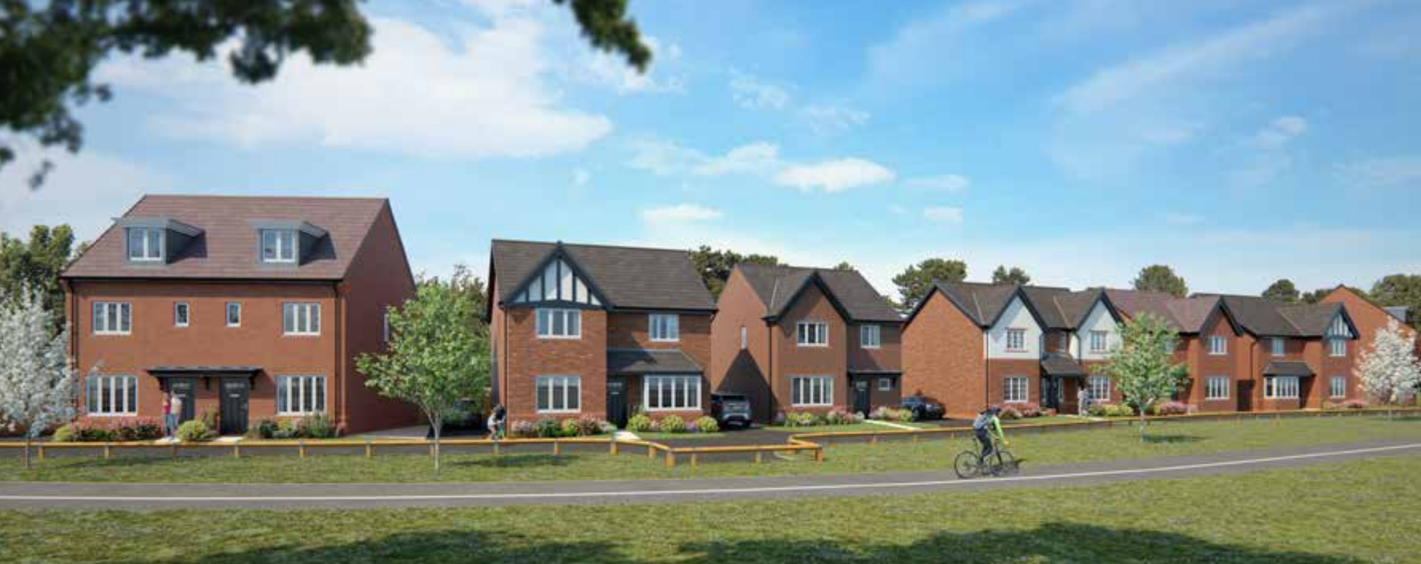
Artists impression showing the shared path leading towards the Riverside Community Park - Click image to enlarge
Vehicular access
Access to the northern parcel which comprises the majority of homes will be taken via new spur from the existing roundabout. A small number of homes in a southern parcel will be served by a separate dedicated access a short distance to the south where there is an existing access serving the Severn Trent Water pumping station.
Planning application documents
A full planning application for the first phase of Penkridge North has been submitted by Bloor Homes to South Staffordshire District Council. The planning application can be viewed on the District Councils dedicated planning page here.
You can download the main planning application document, the Design & Access Statement, which includes more detail on all the information presented above by clicking here.
Any questions?
Please get in touch with any comments or questions and we will be happy to assist. You can get in touch via the dedicated contact form here.


