The area covered by St Philips’ Outline Planning Application is shown shaded in red on the following plan:
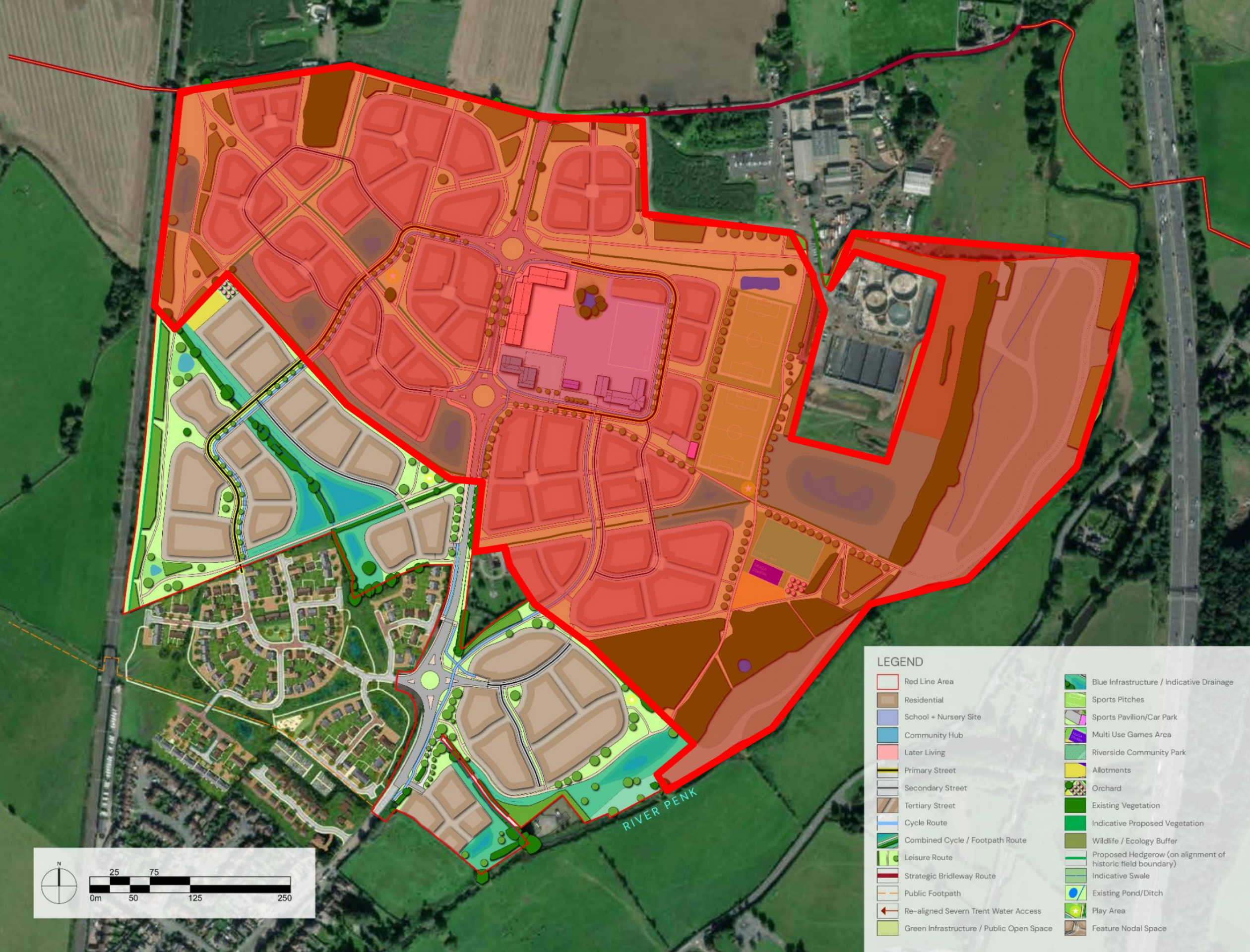
Strategic masterplan with St Philips Outline Application area shaded red - Click image to enlarge
Outline Planning Application
An Outline Planning Application sets out general principles of development, such as number of homes, facilities and access and includes illustrative layouts. If approved, an Outline Planning Application is then followed by further planning applications called Reserved Matters Planning Applications which set out the details of development, including house types, architecture, detailed layouts etc. These Reserved Matters Planning Applications would be subject to further consultation with the local community, providing a further opportunity for local people to help shape the details of the plans.
The Outline Planning Application submitted by St Philips is for the northern section of the strategic site and incorporates the following:
- Up to 750 high-quality homes in a range of styles and tenures.
- At least 40 of these homes will be Specialist Older Peoples’ Housing Units.
- 40% of the new homes will be affordable homes in a range of tenures, including social housing, shared ownership, and First Homes.
- A new First School and nursery to meet the needs of the new neighbourhood.
- A community hub incorporating local convenience retail, commercial space, and a potential food/drink establishment.
- A mobility hub providing sustainable transport opportunities.
- A network of Active Travel routes, including a Strategic Active Travel Route linking the new neighbourhood with the village centre.
- A new Riverside Community Park (the first section of which is being provided in the Full Planning Application submitted by Bloor Homes).
- New sports pitches and changing facilities.
- The retention of existing woodland.
- Extensive areas of new public open space on land currently inaccessible to the public.
- Community allotments.
- Children’s play areas.
If the Outline Planning Application is approved by South Staffordshire District Council, it will then be followed by further community consultation to inform subsequent Reserved Matters Planning Applications which will establish the details of the phases of development as they come forward.
Strategic masterplan
You can view an interactive masterplan for proposed new neighbourhood at Penkridge North, of which this Outline Planning Application forms the northern section, here.
New homes
The Outline Planning application is for up to 750 new homes in a mix of styles and tenures. At least 40 of the new homes will be dedicated Specialist Older People’s residential units.
Affordable housing
40% of new homes will be affordable homes, including:
Social Rent - Homes for social rent through the local authority/local housing association.
Shared ownership –This is a more affordable way for people to buy their own home. Under shared ownership, the purchaser buys an initial percentage of the property, between 10% and 75%, and pay a reduced rent on the rest to a local housing association.
First Homes –First Homes are homes that are sold on at a discount of at least 30% against the market value, and with a price cap of £250,000 applied. Eligibility criteria apply that ensure they are only available to people on lower incomes such as key workers. When a First Home is sold to its first owner, a legal restriction is entered onto the Title Register. This restriction is intended to ensure that the title cannot be transferred to another owner unless the relevant local authority certifies to HM Land Registry that the First Homes criteria and eligibility criteria have been met, including the discounted sale price.
Sustainable housing
Sustainable construction, energy efficiency and fabric first methods will be incorporated into the scheme proposals at the detailed design stage (Reserved Matters Planning Applications), promoting a high standard construction and sustainability for the development.
Best practice sustainability will be embraced and the following principles will be incorporated in creating the site layout:
- Optimum plot orientation for solar gain with south facing windows to maximise sunlight.
- Ensuring that buildings can be easily adapted to suit different occupiers needs allowing for the expansion of living areas and storage needs, and where practicable making better use of roof spaces. • The provision of facilities for refuse, recycling stores, composting and water butts
- The use of environmentally friendly and sustainable materials, such as locally sourced / recycled materials, aggregates and recycled timber. Resource / energy efficient buildings will be used, potentially with:
- Efficient heating systems, which might include energy saving micro combined heat and power units.
- Low flow showers, smaller baths and dual low flush toilets as part of controlled water demand and use.
- Low carbon lighting, energy controls and management.
- Double and triple glazing, and improved insulation.
Building Regulations set the standards for most aspects of a building’s construction. Part L specifically addresses the requirement for energy conservation and power. Renewable energy can be incorporated into the scheme, however, pursuing fabric first approaches in the first instance will ensure that all occupiers benefit from reduced electricity bills and will achieve reductions in CO2 production.
Design and appearance
As an Outline Planning Application, details such as architecture are not considered in detail, as this is worked up through subsequent Reserved Matters Planning Applications in consultation with local stakeholders. However, the Outline Planning Application for the northern section of Penkridge North incorporates the proposed character areas of Upper Penkridge and Lower Penkside:
Upper Penkridge
It is proposed that the Upper Penkridge character area, on the western side of the A449 corridor, will have a more contemporary style. It could incorporate a greater sense of formality, with a selective number of housetypes and simple building forms. It could incorporate features such as timber effect cladding to reflect nearby woodland. Features to take advantage of views from higher ground and across open space corridors could also be included.
Lower Penkside
The Lower Penkside character area, on the eastern side of the A449 closer to the river, would see buildings take cues from the traditional vernacular & nearby heritage assets. It would have a more Informal character with a variety of housetypes unified by a common building line. Buildings would be orientated to take advantage of views over the river and towards Cannock Chase.
You can find more information on the proposed character areas in Penkridge North in the Design and Access Statement which forms part of the planning submissions via the link in the Planning Application Documents section towards the bottom of this page.
Community hub and school
The community hub within Penkridge North will provide a focal point for the new community at a scale that does not undermine the importance of the historic centre and range of facilities within Penkridge.
The community hub will include:
A Local Centre – Retail, hospitality and other services
Stakeholder engagement has highlighted that the local community would welcome some retail provision to provide variety to the existing retail offer in the village. However, it is also important that the new provision does not directly compete with the village centre offer. A retail unit of up to 500m2 is, therefore, proposed to accommodate a range of small shops or a larger single food store.
The local centre will also accommodate other services to meet the day-to-day needs of residents, which may include a hot food takeaway, cafe, pub/ bar, community work space or other commercial services such as hairdressers and the like. Precisely what will be provided cannot be determined at this time, but the total floorspace will be up to 1,000m2 (including the 500m2 of the retail uses).
Community Space
A dedicated community building is not proposed. This reflects the feedback received during the stakeholder engagement, where respondents instead favoured investing in the maintenance of the existing community buildings in the village. However, a small community space could be provided within the local centre building to serve specific local needs in the neighbourhood.
A first school and nursery site
The community hub will accommodate a 1.5ha new first school and nursery site, as required by the emerging allocation policy. Following engagement with the County Council and in response to consultation feedback, it has been moved away from the A449 corridor and located to the east of the local centre to ensure that there are no traffic conflicts on the A449.
Plaza
A plaza will provide an attractive setting for the community hub and a place to meet and interact at the heart of the development. It will accommodate the interface between the active travel and public transport infrastructure and the uses within the local centre, and will also provide an appropriate level of car parking.
In a nod to its rural context, key buildings within the community hub, including the school, will reflect traditional farm buildings in a more contemporary way, using simple forms, roof profiles and materials to create a distinctive identity at the heart of the new development.
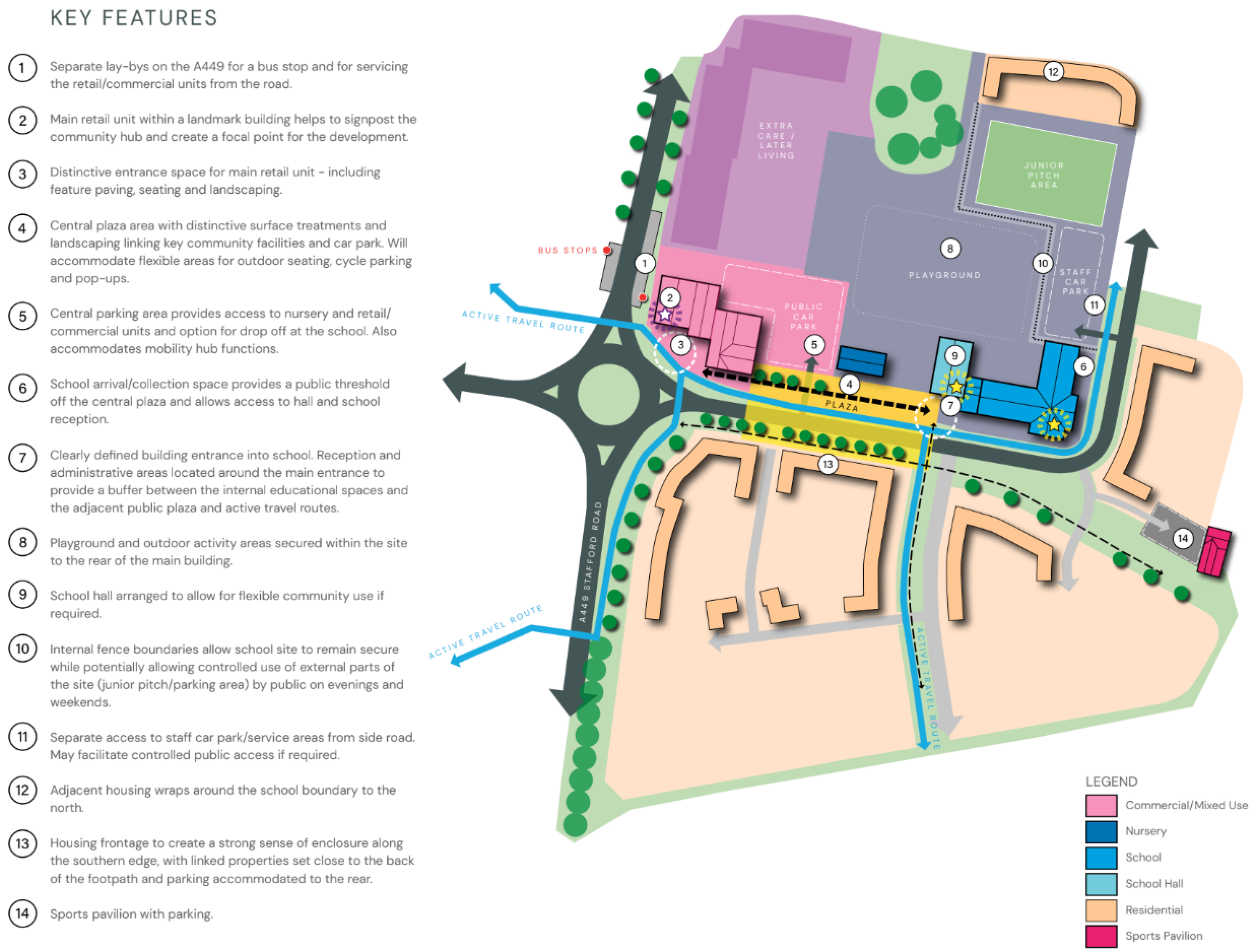
Community hub key features - Click image to enlarge
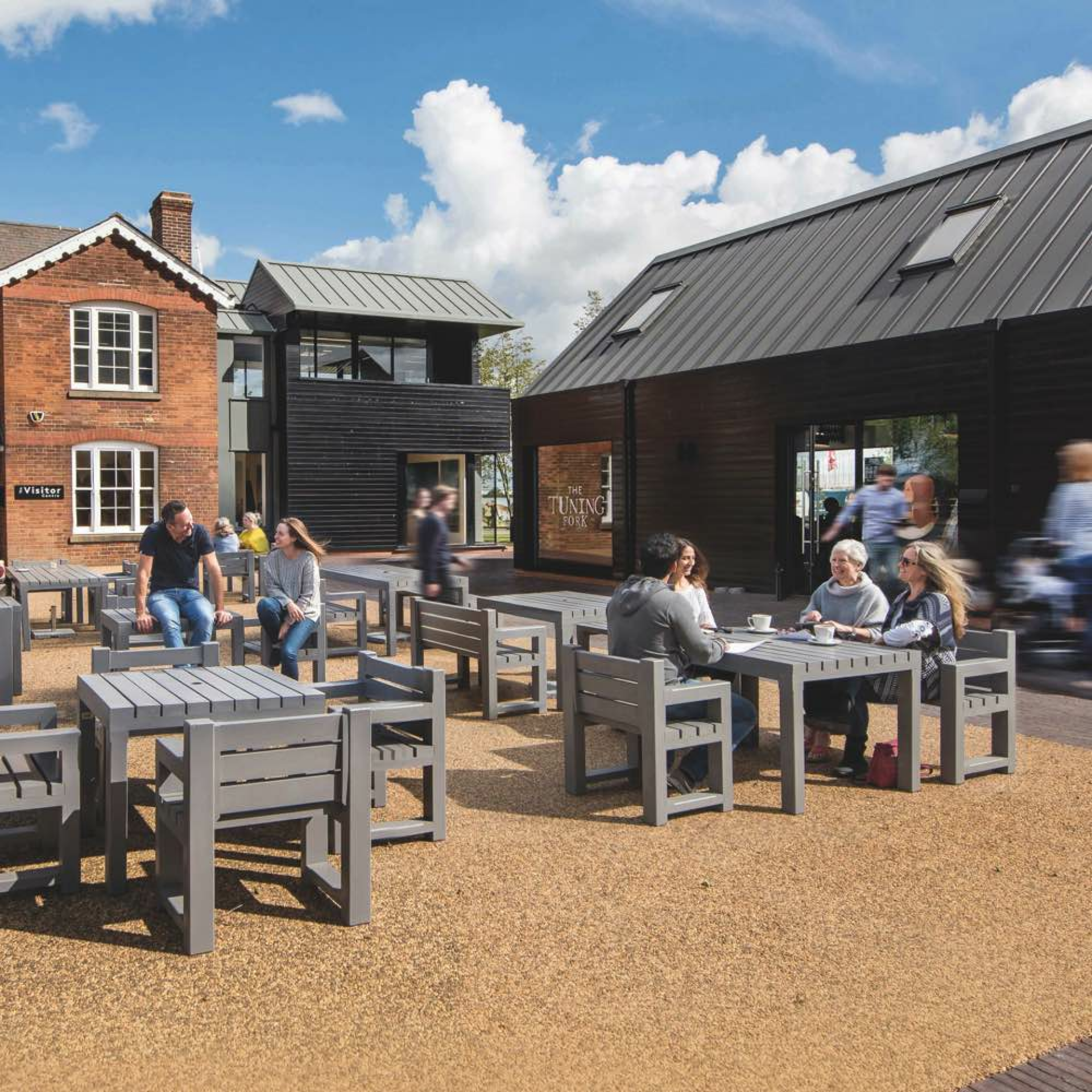
An example of a community hub from another development - Click image to enlarge
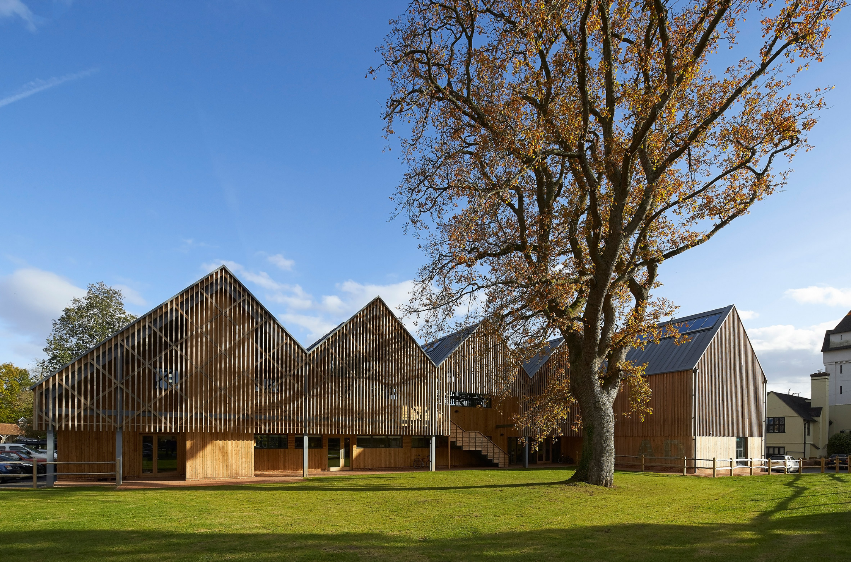
An example of a primary school from another development - Click image to enlarge
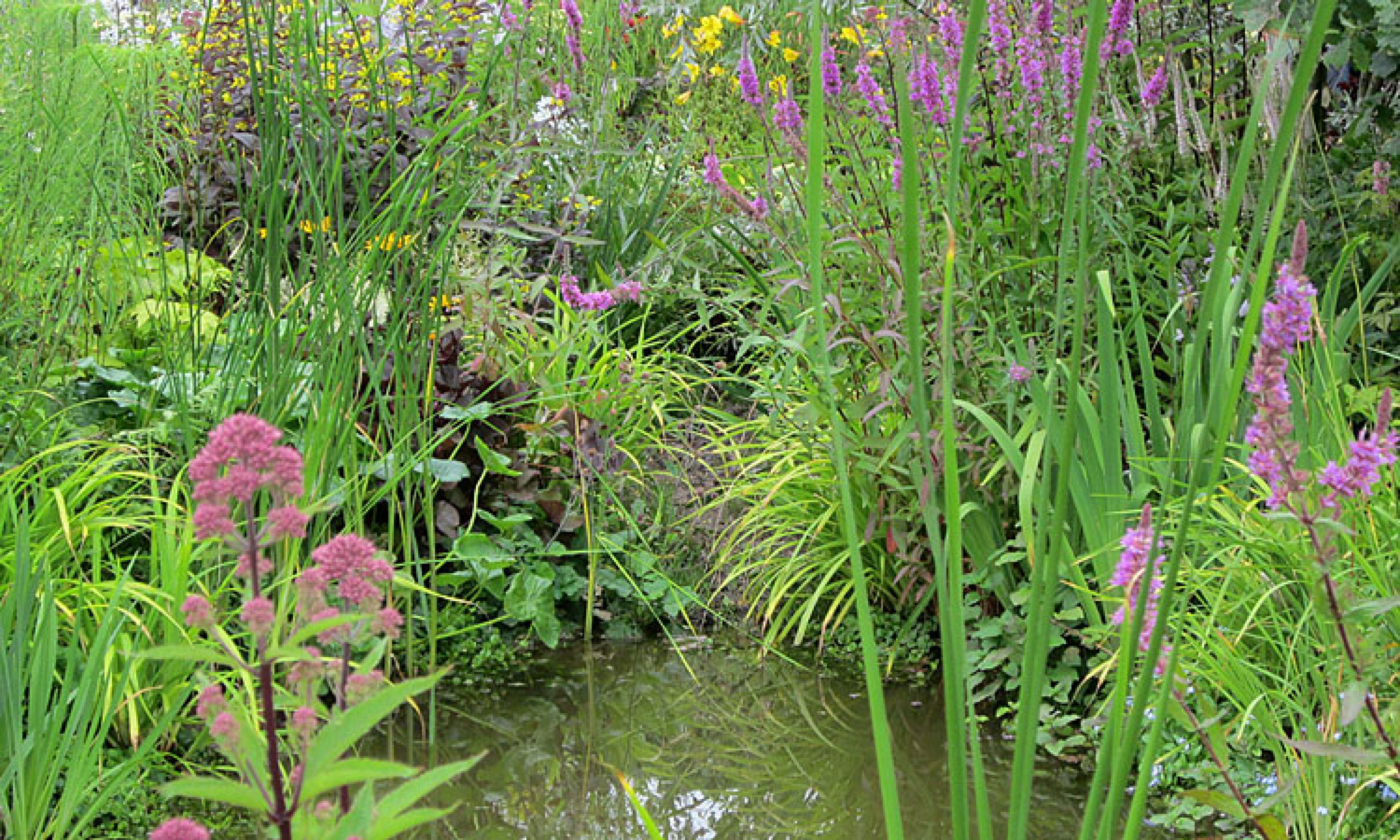
Community riverside park
The Community Park provides a key open space in the development that will allow people to escape into nature, opening up the western side of the Penk to public access for the first time.
Biodiversity and habitat creation is a key feature of the park and this will be enhanced and protected through a careful maintenance regime and carefully considered human intervention.
A circular walking route will be provided that through hard surfacing will ensure accessibility, whilst key areas will be designed to provide important views over the surrounding area.
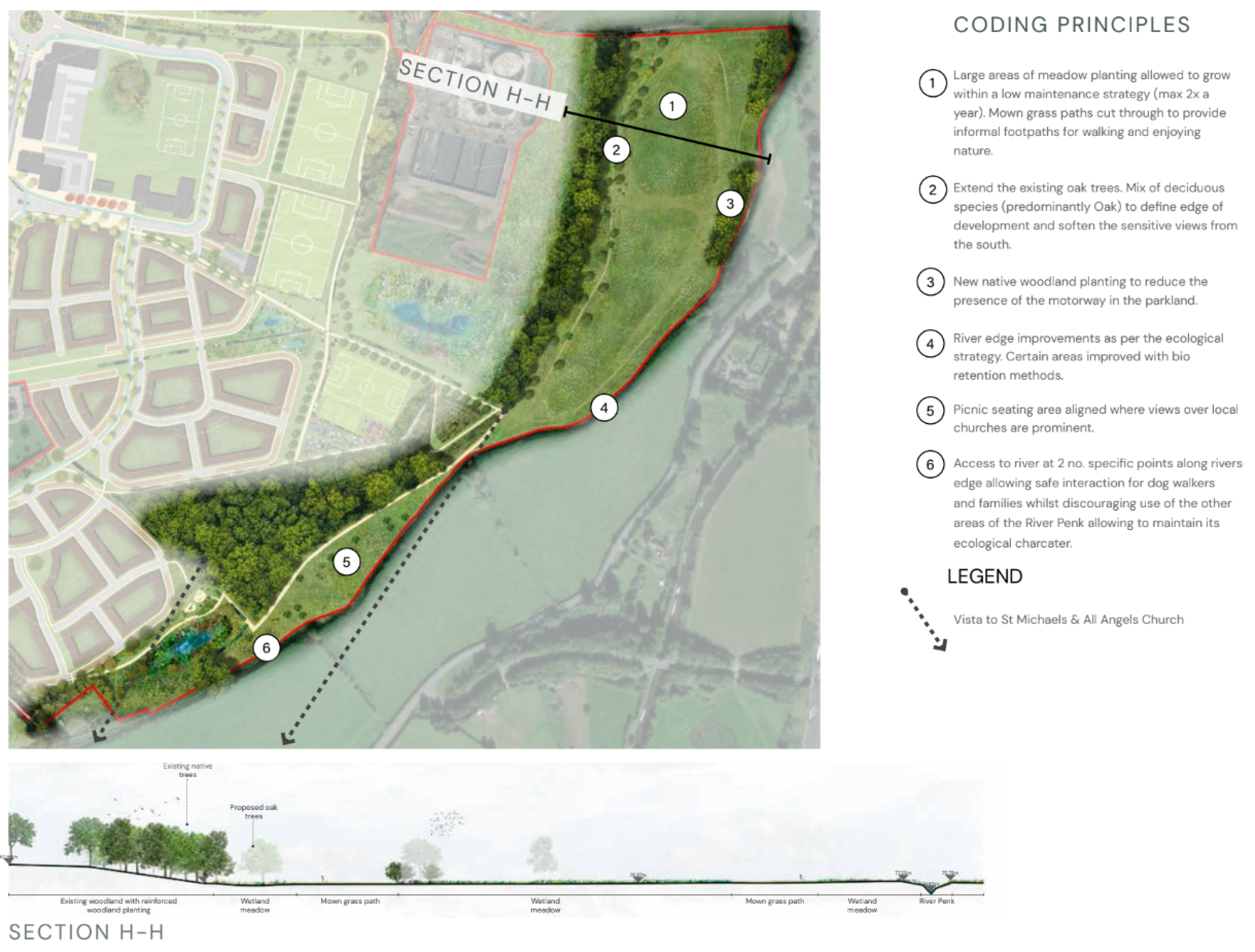
Community riverside park - Click image to enlarge
Sports and leisure facilities
The Sports and Recreation area provides an important recreational facility for the new neighbourhood and will be designed to integrate active uses for the surrounding community; becoming a hub for health and wellbeing.
A sports pavilion will be provided that is well connected to the local centre and active travel network. This would include facilities such as changing room, toilets and showers. A plaza will be provided here to allow the space to become a meeting area and activity hub for groups.
Final provision will be determined alongside consultation with local people an in collaboration with the local authority to ensure they balance with the needs of the community.
Sports pitches will be provided with suitable drainage so that all year-round activity can be provided. We are currently proposing 2 full-size football pitches at the sports pavilion, as well as an under-11s/12s 9x9 pitch. A further junior pitch is also being provided at the new school site.
A Multi-Use Games Area is also proposed, in response to feedback from our previous round of public consultation.
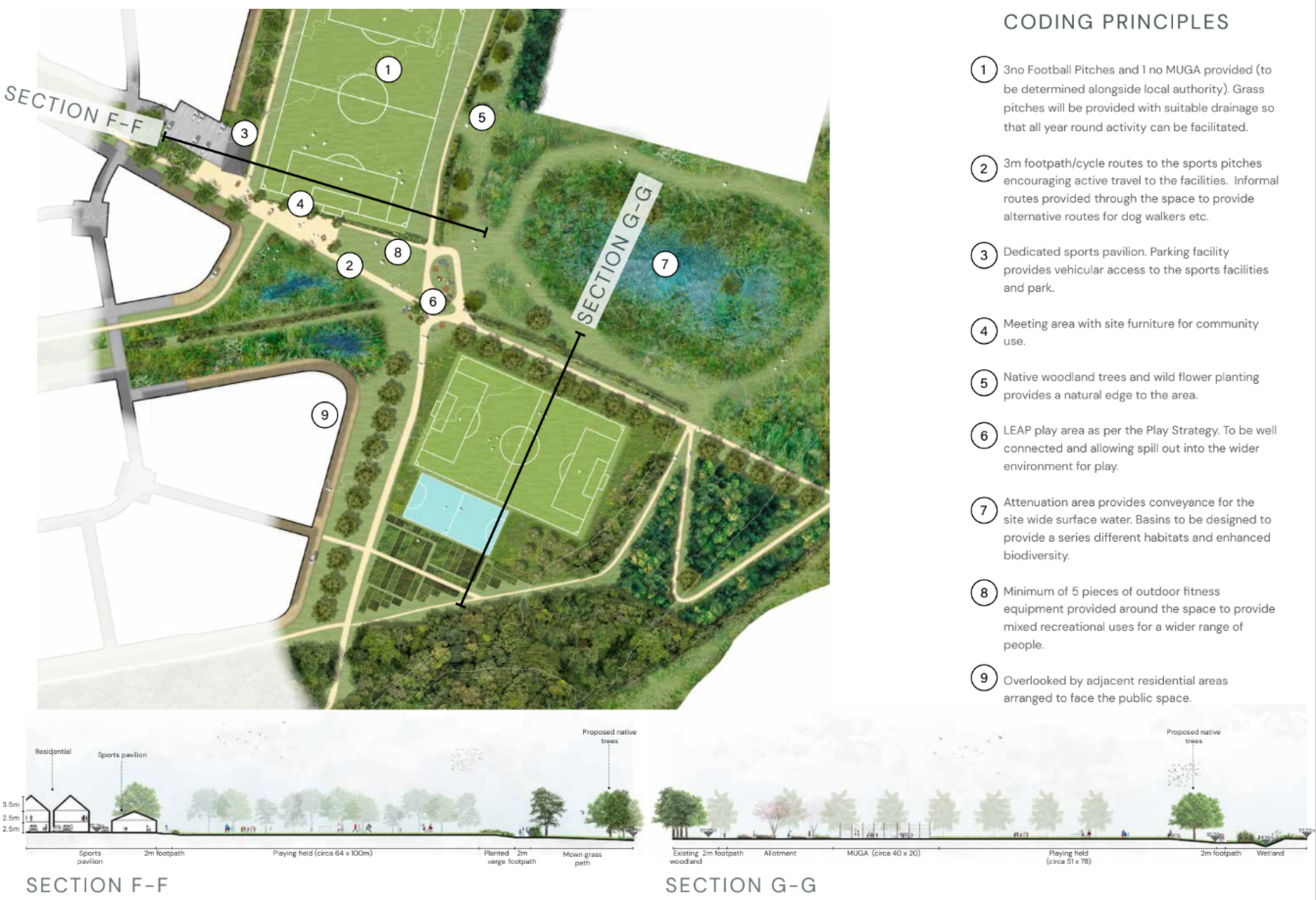
Sports and leisure facilities - Click image to enlarge
Play areas
In addition to the formal sports and recreation area, it is also proposed to provide a mix of Local Equipped Areas of Play (LEAPs) and Local Areas of Play (LAPs) across the neighbourhood.
Green infrastructure and biodiversity
The Masterplan for the development of the site has been designed to include a network of accessible and interconnected green spaces, which will integrate the development into its setting, deliver a range of benefits for both people and nature, and respond positively to the local context. In so doing, it will enhance landscape character and restore historic landscape elements.
Green spaces will be designed to integrate the retained existing boundary hedgerows. Existing trees and woodland will be integrated into green corridors and supplemented with additional tree and scrub planting and species rich grassland.
The development as a whole will achieve a minimum 10% net gain to biodiversity by creating valuable habitats where there is currently arable land of low ecological value. There are opportunities for the creation of extensive areas of locally important habitats such as ponds, hedgerows, deciduous woodland and species rich neutral meadows.
Opportunities for food growing will be offered through the provision of areas of allotments on both the eastern and western sides of the A449 corridor.
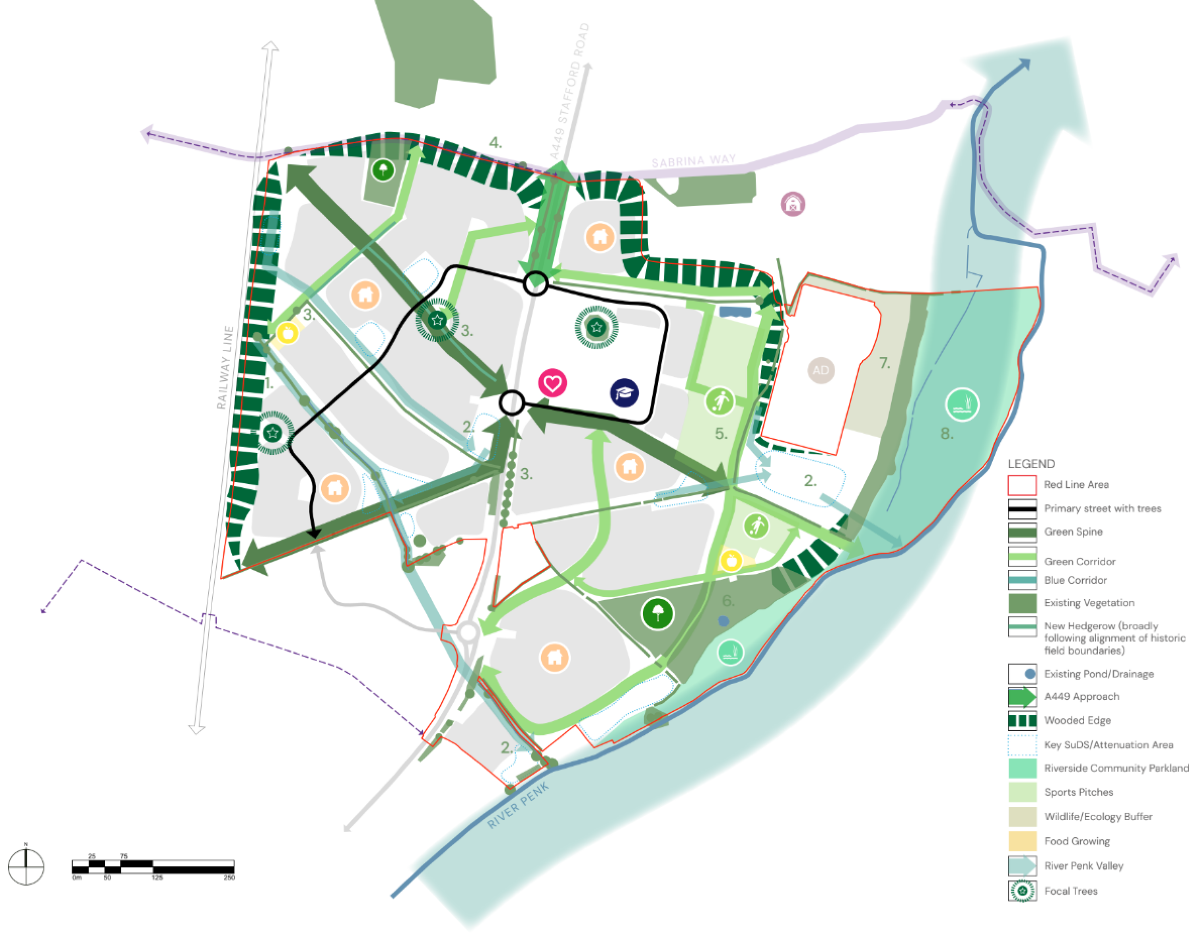
Green infrastructure and biodiversity - Click image to enlarge
Click image to enlarge
Click image to enlarge
Delivery strategy
The following plan shows the anticipated delivery and phasing strategy for Penkridge North over a number of years, subject to planning permissions.
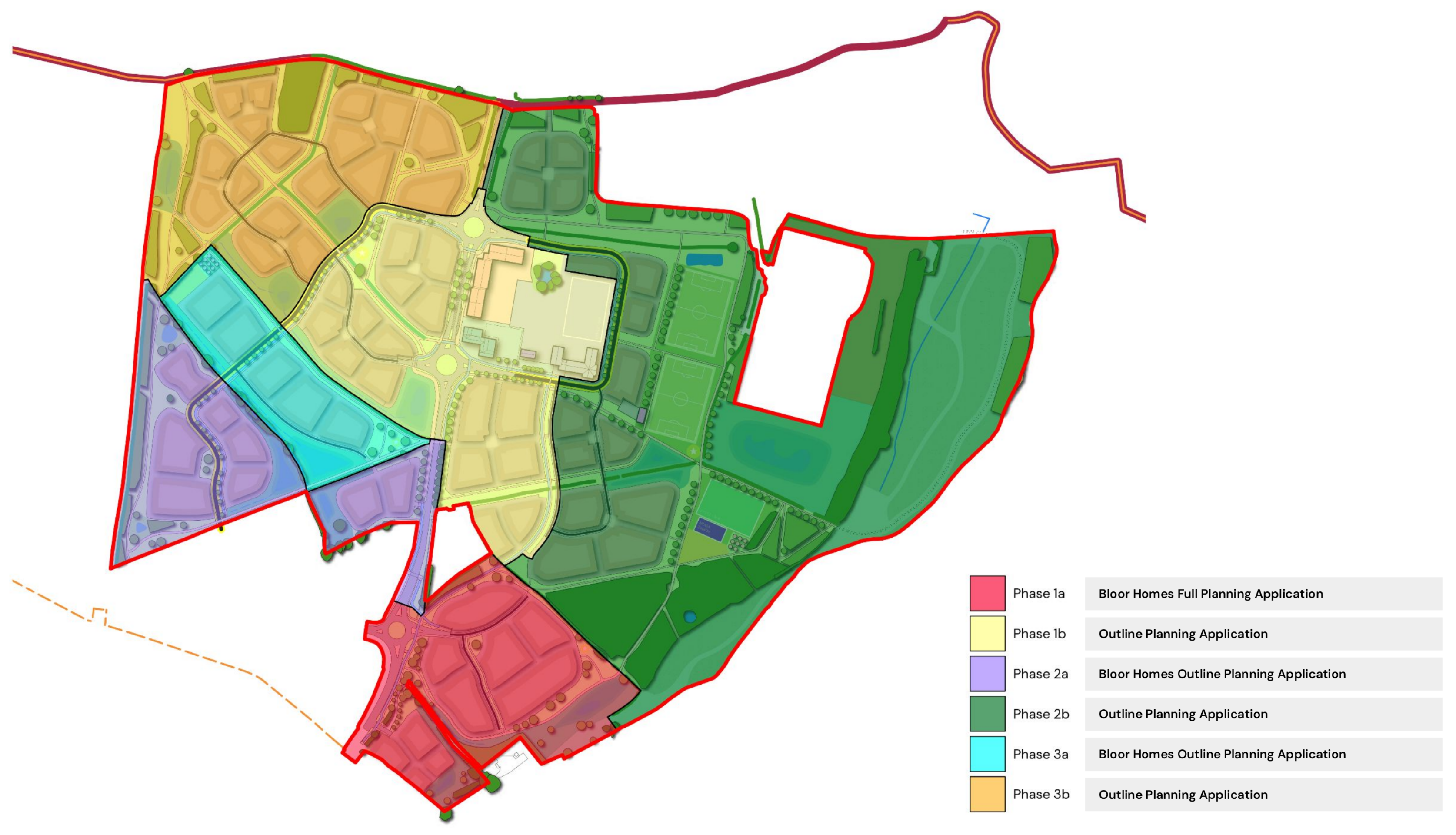
Delivery strategy - Click image to enlarge
Access and movement
Site access
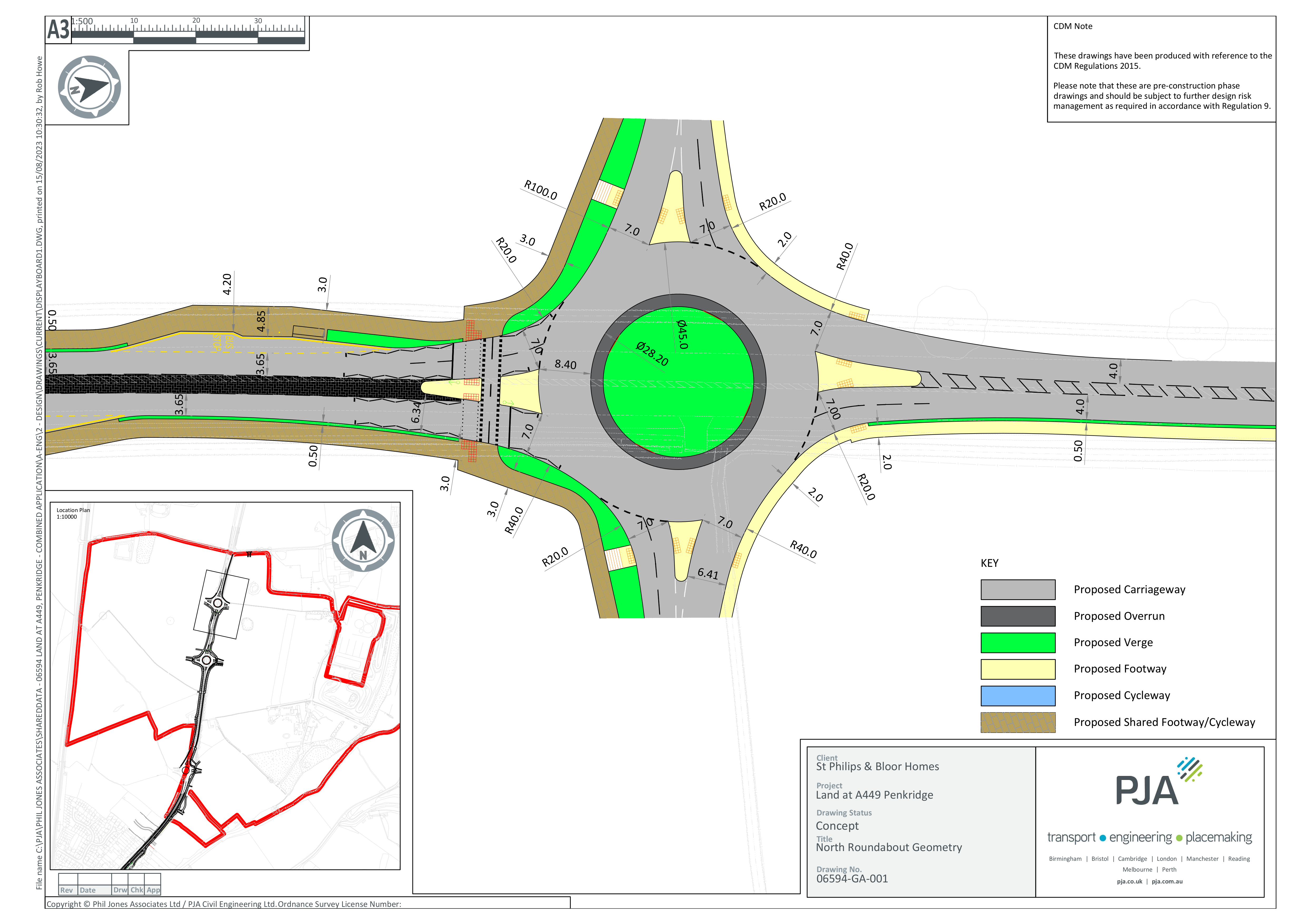
Access to the development areas will principally be provided from Stafford Road via two new four arm roundabouts that will provide access to the east and west development parcels, as well as provision of a fourth arm to the existing roundabout which serves the Bloor Homes development that is currently being delivered (this latter element forms part of the Bloor Homes full planning application submitted previously).
The northern roundabout will act as a gateway feature into the village. That will mark the new northern settlement edge and provide an effective speed reduction measure to assist in the transition from 60mph to 40mph, and then to 30mph.
A second roundabout will be provided at the centre of the site, and will serve both residential development and the community / green space hubs that are located to the east of Stafford Road.
The development areas to the east and west of Stafford Road will be served via a looped internal arrangement of tree lined primary streets linking the roundabout accesses.
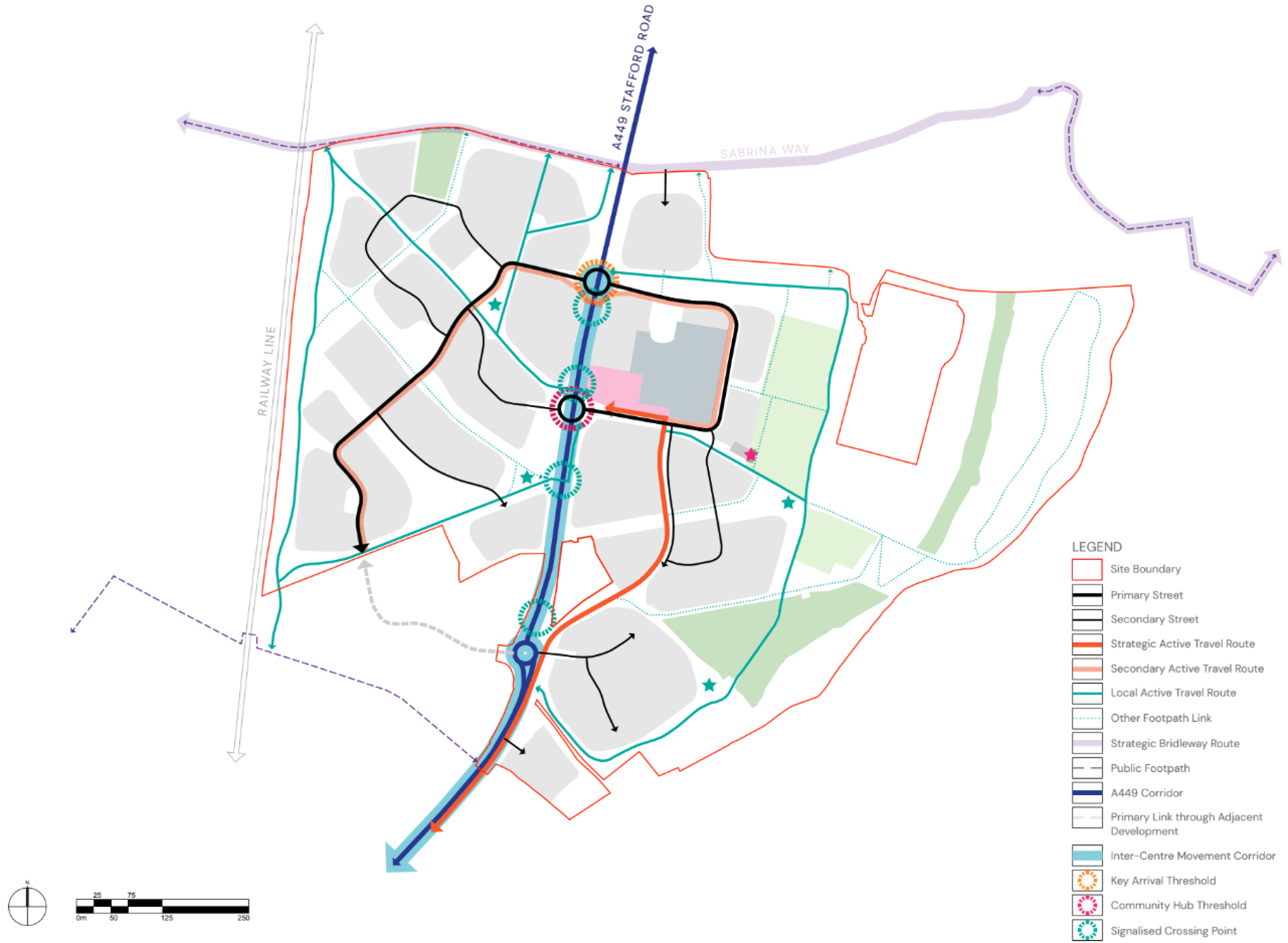
The access and movement strategy for Penkridge North - Click image to enlarge
Stafford Road Corridor
There is a wide highway corridor as Stafford Road passes through the site. That provides the opportunity for its enhancement to better meet the needs of all users, whilst ensuring that it integrates rather than separates the new neighbourhood.
Dedicated crossing points will be provided to aid movements across Stafford Road. That will include signalised crossing points at key desire lines to ensure safe and convenient active travel movements between the development areas.
Click image to open gallery of plans
Active travel
The proposed active travel strategy aspires to improve connectivity for walking, cycling and other forms of active travel for journeys both within the new neighbourhood, and for journeys between the site and key local amenities within Penkridge village centre. The strategy is underpinned by national guidance and best practice and has been developed in consultation with Staffordshire County Council highways.
The active travel strategy will focus on providing high quality infrastructure to support active travel throughout the site and further afield with a particular focus on the A449 corridor between the site and Penkridge village centre. The key aspects proposed are as follows:
- A range of cycle infrastructure, comprising segregated cycle routes, shared footway/cycleways, low trafficked roads suitable for on-road cycling and green leisure routes within the development site;
- continuous segregated cycle route and separate footway between Penkridge village centre and the proposed local centre on-site. It is anticipated that this will route alongside the A449 between the village centre and the southern part of the site, before routing internally within the eastern side of the site.
- A staged approach to pedestrian and cycle infrastructure alongside the A449 within the site boundary, as follows:
- Stage 1 – Segregated cycleway and footway on one side of the carriageway between the Bloor Phase 1 roundabout and central proposed roundabout. Additional footway on the other side of the carriageway;
- Stage 2 – Shared footway/cycleway on both sides of carriageway between the two proposed roundabouts; and
- Stage 3 – A footway on one side of the carriageway north of the proposed roundabout to tie into the existing facility.
A series of signalised and unsignalised pedestrian and cycle crossing points will be provided at junctions and various points along the A449 to ensure connectivity. Proposed crossing point locations have been identified to tie into leisure routes and key connections within the masterplan to promote permeability through the site on foot and by cycle.
Planning application documents
An Outline Planning Application for the northern section of Penkridge North has been submitted to South Staffordshire District Council by St Philips. The planning application can be viewed on the District Council’s dedicated planning page here.
You can download the main planning application document, the Design & Access Statement, which includes more detail on all the information presented above by clicking here.
Any questions?
Please get in touch with any comments or questions and we will be happy to assist. You can get in touch via the dedicated contact form here.