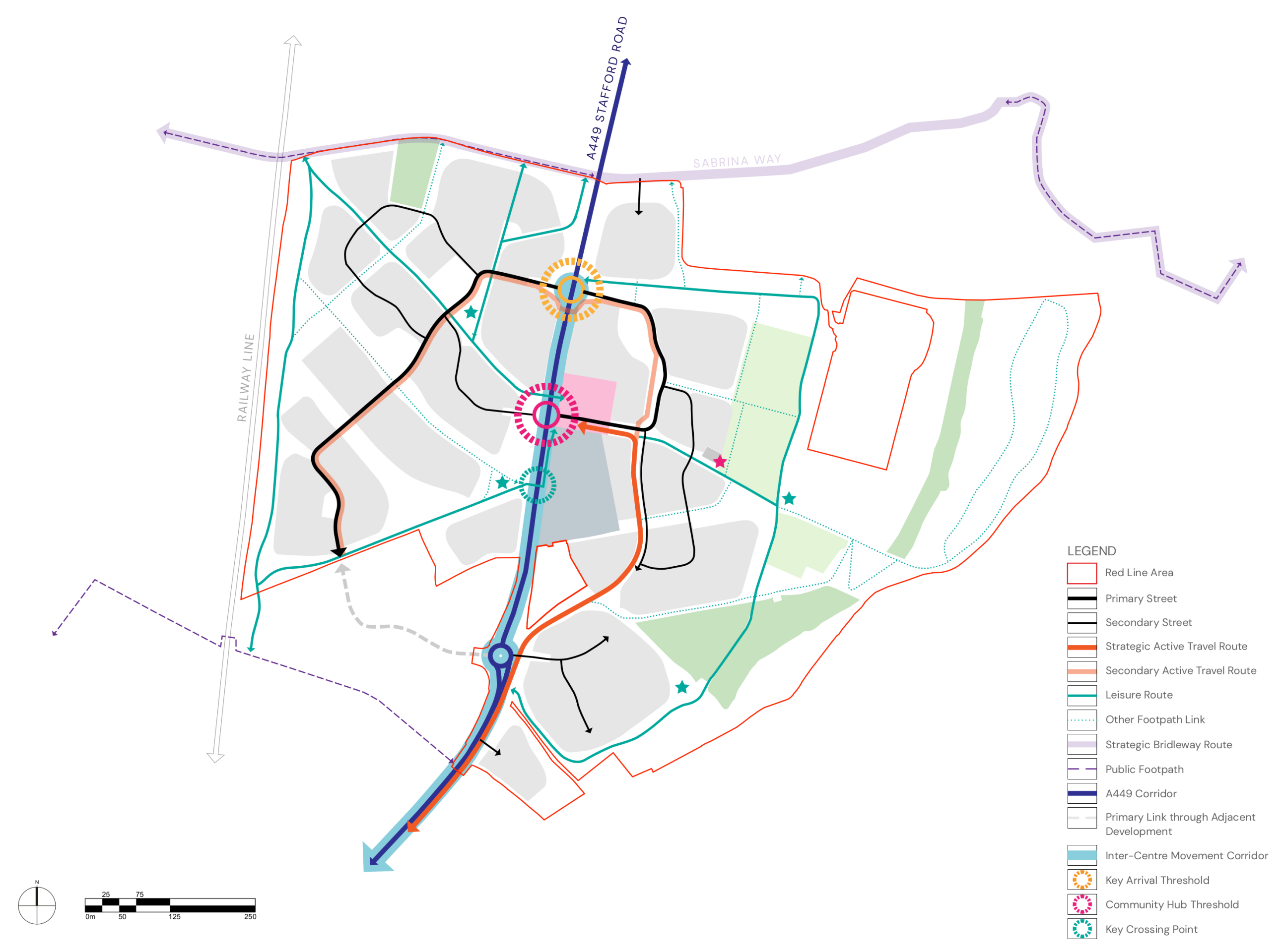
Overall access and movement strategy plan - Click image to enlarge
Site access
Access to the development areas will principally be provided from Stafford Road via two new four arm roundabouts that will provide access to the east and west development parcels, as well as provision of a fourth arm to the existing roundabout which serves the Bloor Homes development that is currently being delivered.
The northern roundabout will act as a gateway feature into the village. That will mark the new northern settlement edge and provide an effective speed reduction measure to assist in the transition from 60mph to 40mph, and then to 30mph.
A second roundabout will be provided at the centre of the site, and will serve both residential development and the community / green space hubs that are located to the east of Stafford Road.
The development areas to the east and west of Stafford Road will be served via a looped internal arrangement of tree lined primary streets linking the roundabout accesses.
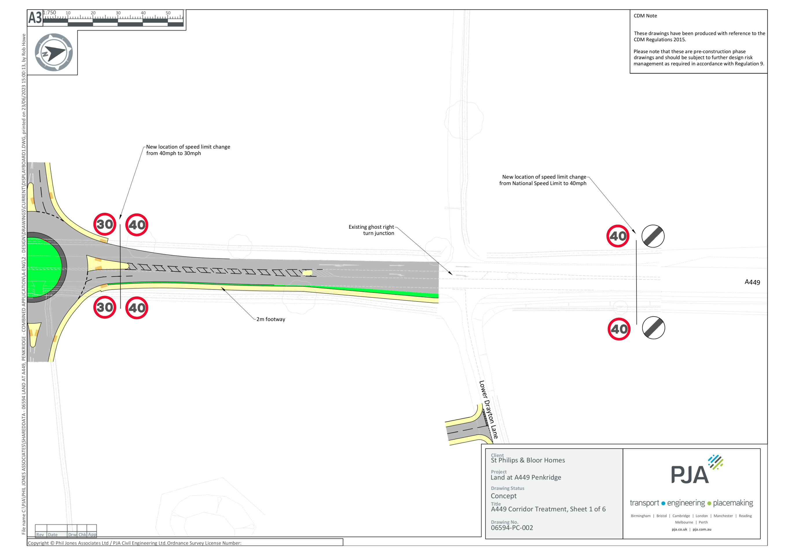
Stafford Road Corridor
There is a wide highway corridor as Stafford Road passes through the site. That provides the opportunity for its enhancement to better meet the needs of all users, whilst ensuring that it integrates rather than separates the new neighbourhood.
Dedicated crossing points will be provided to aid movements across Stafford Road. That will include signalised crossing points at key desire lines to ensure safe and convenient active travel movements between the development areas.
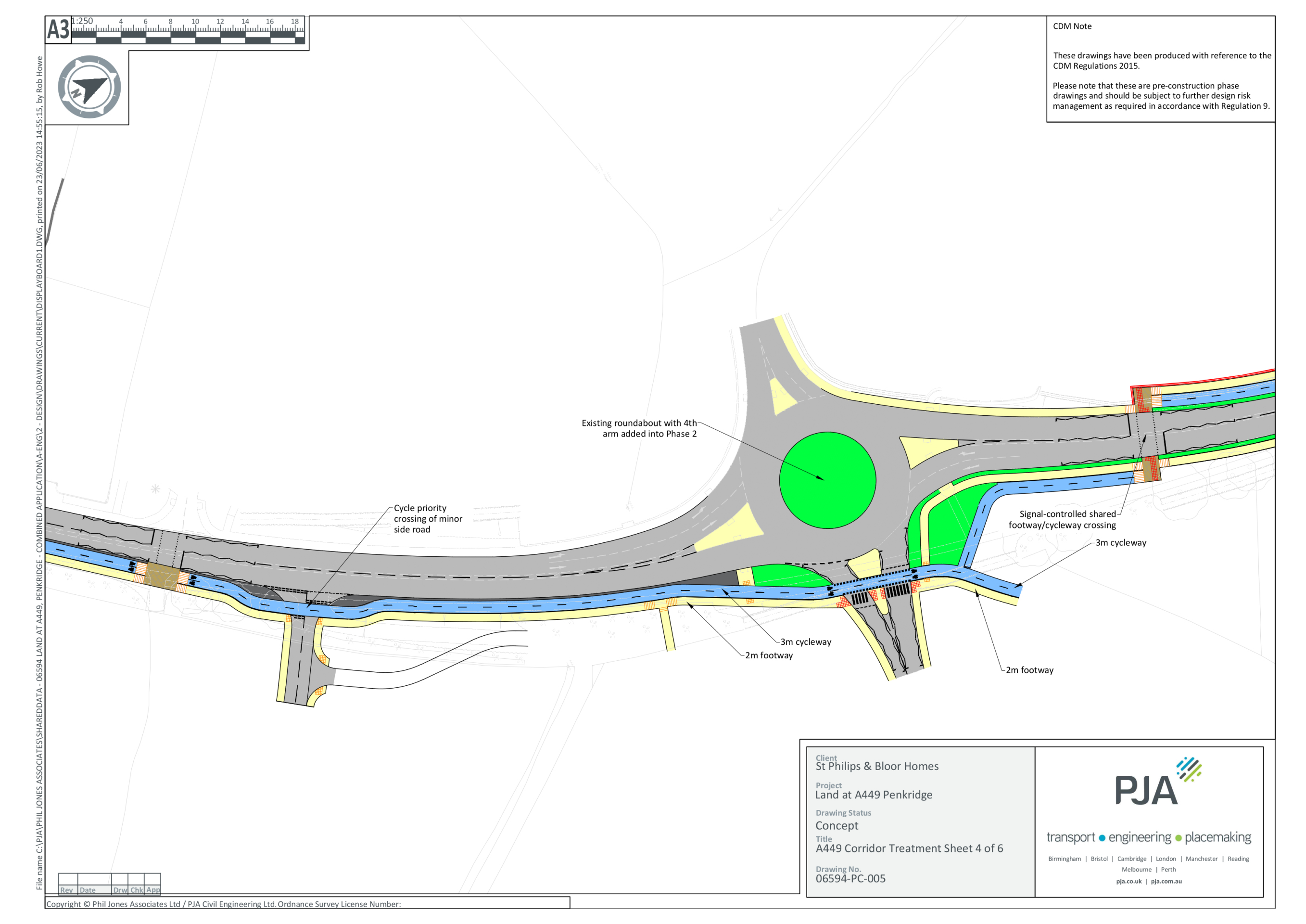
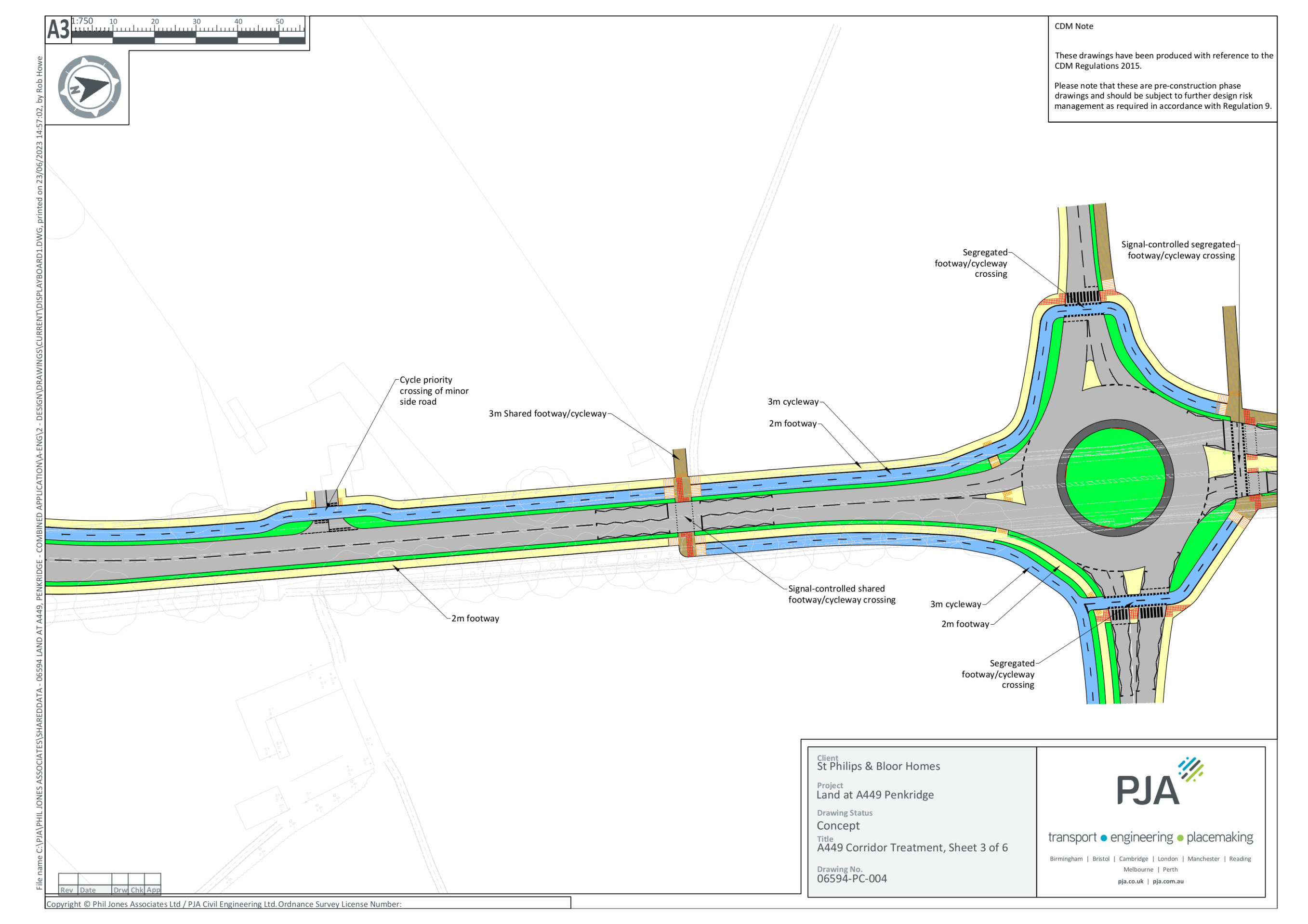
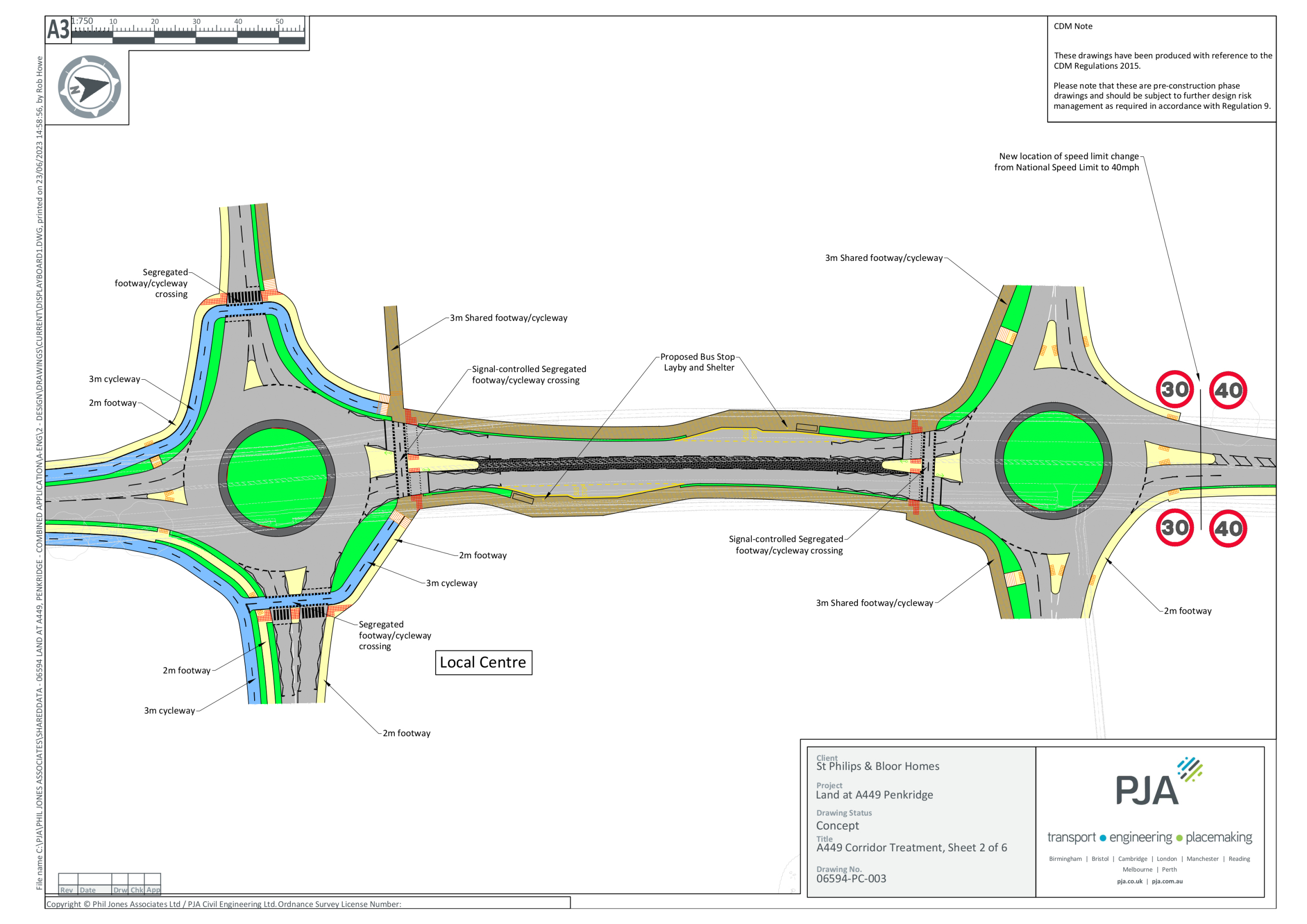
You can view details of the proposed improvements to the A449 corridor in the following gallery of technical drawings - click to open
Active travel
The proposed active travel strategy aspires to improve connectivity for walking, cycling and other forms of active travel for journeys both within the new neighbourhood, and for journeys between the site and key local amenities within Penkridge village centre. The strategy is underpinned by national guidance and best practice and is being developed in consultation with Staffordshire County Council highways.
The active travel strategy will focus on providing high quality infrastructure to support active travel throughout the site and further afield with a particular focus on the A449 corridor between the site and Penkridge village centre. The key aspects proposed are as follows:
- A range of cycle infrastructure, comprising segregated cycle routes, shared footway/cycleways, low trafficked roads suitable for on-road cycling and green leisure routes within the development site;
- continuous segregated cycle route and separate footway between Penkridge village centre and the proposed local centre on-site. It is anticipated that this will route alongside the A449 between the village centre and the southern part of the site, before routing internally within the eastern side of the site.
- A staged approach to pedestrian and cycle infrastructure alongside the A449 within the site boundary, as follows:
- Stage 1 – Segregated cycleway and footway on one side of the carriageway between the Bloor Phase 1 roundabout and central proposed roundabout. Additional footway on the other side of the carriageway;
- Stage 2 – Shared footway/cycleway on both sides of carriageway between the two proposed roundabouts; and
- Stage 3 – A footway on one side of the carriageway north of the proposed roundabout to tie into the existing facility.
- A series of signalised and unsignalised pedestrian and cycle crossing points will be provided at junctions and various points along the A449 to ensure connectivity. Proposed crossing point locations have been identified to tie into leisure routes and key connections within the masterplan to promote permeability through the site on foot and by cycle.

Click image to enlarge
Mobility hub
Mobility hubs are accessible spaces where public, shared and active forms of travel are co-located alongside public realm and community facilities to facilitate safe, convenient and active journeys.
A mobility hub is proposed within the community hub adjacent to Stafford Road, which will remain the key bus corridor.
Sabrina Way
The Sabrina Way is a bridleway running east-west along the northern boundary of the site. It is outside of the development area and will be unaffected by the proposals. We are proposing additional woodland planting to enhance and protect the setting of the Sabrina Way. Links from the new public footpath network in the new neighbourhood to the Sabrina Way will also be provided.

Click image to enlarge
Click image to enlarge